At some point in 2019, PennDOT officials expect parts of Interstate 70 could sink up to five feet between the West Virginia line and the Claysville interchange in Washington County due to longwall mining.
“When longwall mining occurs, the interstate can be expected to settle about two to five feet in some areas,” PennDOT District 12 Executive Joseph Szczur wrote in the district’s latest newsletter. “Because of this concern, we have a multi-phase monitoring plan in place to keep track of all the interstate longwall mining activities,”
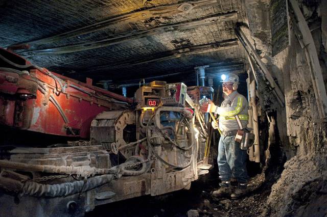
Longwall mining removes coal in long strips below the ground, where a cutting head moves back and forth across a panel of coal about 1,200 to 1,400 feet wide and more than 10,000 feet long. The cut coal falls onto a conveyor belt and is carted away. The process occurs anywhere between 300 and 1,300 feet underground.
It takes place under hydraulic roof supports that are advanced as the seam is cut. The roof in the mined-out areas, according Szczur, falls behind the supports as it advances.
“When it falls, the surface also sinks,” he wrote.
The Alliance Coal Company’s Tunnel Ridge Mine will have a working panel beneath I-70 during the next phase of longwall mining, and Szczur said the process will occur nine more times between now and 2038 under the highway.
PennDOT will have single-lane restrictions and a 45 mile-per-hour speed limit in place to slow traffic, and plan to keep a close eye on mining effects in several ways:
• Alliance will provide daily updates on the mining conditions.
• 3D scans will show the existing contour of the land for continual comparisons.
• Several measuring tools will be in place to show ground movement at the surface, and will function as an alarm system. When movement exceeds an allowable limit, a message is sent alerting personnel trained to respond.
• Continual human inspection will occur.
• Survey data will be collected to monitor and plan for future events.
Controversy over longwall mining is not new in western Pennsylvania.
In 2013, after a six-year fight over whether longwall mining caused subsidence and cracks in the dam at Ryerson Station State Park in Greene County, the Department of Conservation and Natural Resources reached a $36 million deal with Consol Energy to help rebuild the dam. Consol officials did not admit fault as part of the deal.
In 2006, an Ohio coal company filed a federal lawsuit against former Gov. Ed Rendell and former DEP Secretary Kathleen McGinty over regulatory enforcement related to a longwall mining operation in Washington County.
PennDOT officials are taking steps to prepare for any effects of the 2019 mining.
For minor damage such as cracking and compression bumps, county maintenance and contractors will keep the road safe for travel by milling and spot patching, according to Szczur.
“After the mining is out from beneath the section of the interstate and the ground settling has finished, we will use emergency contracts to repair the surface damage,” he wrote. “Our main goal is to protect the traveling public and keep the millions of Interstate 70 motorists moving across Pennsylvania.”
Patrick Varine is a Tribune-Review staff writer. You can contact Patrick at 724-850-2862, pvarine@tribweb.com or via Twitter @MurrysvilleStar.